| Magnitude | 5.7 |
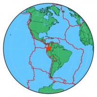
| Region | COLOMBIA-ECUADOR BORDER REGION |
| Date time | 2014-10-20 19:33:22.5 UTC |
| Location | 0.719 ; -77.982 |
| Depth | 10 km |
| Distance | 44 km N of Ibarra, Ecuador / pop: 132,000 / local time: 14:33:22.5 2014-10-20 12 km NW of El Ángel, Ecuador / pop: 3,900 / local time: 14:33:22.5 2014-10-20 |
All data providers for this event:
Landsamt fur Geologie, Rohstoffe und Bergbau -- Freiburg, Germany (LED)Geophysical Institute of the Academy of Sciences -- Prague, Czech Republic (GFU)
Montenegro Seismological Observatory -- Podgorica, Montenegro (MSO)
GeoForschungsZentrum (GFZ) -- Potsdam, Germany (GFZ)
Inst. de Astron., Geof. e Ciencias Atmos., Univ. de S?o Paulo, Brazil -- , Brazil (VAO)
British Geological Survey (Global Network) -- Edinburgh, United Kingdom (BGSG)
Bundesanstalt fur Geowissenschaften und Rohstoffe, German Regional Seismograph Network -- Hannover, Germany (BGR)
National Earthquake Information Center, U.S. Geological Survey -- Golden, United States (NEIC)
GeoSphere Austria -- Vienna, Austria (GSA)
Instituto Geografico Nacional -- Madrid, Spain (IGN)
Laboratoire de Detection et de Geophysique -- Bruyeres-le-Chatel, France (LDG)
HUN-REN EPSS Kövesligethy Radó Seismological Observato -- Budapest, Hungary (BUD)
Geophysical Survey of the Russian Academy of Sciences -- Obninsk, Russia (GSRAS)
Kandilli Observatory and Earthquake Research Institute -- Istanbul, Turkey (KOERI)
Further information can be found at:
National Earthquake Information Center, U.S. Geological Survey -- Golden, United States (NEIC)GeoForschungsZentrum (GFZ) -- Potsdam, Germany (GFZ)
Instituto Geofisico del Peru -- Lima, Peru (LIM)
Escuela Politecnica Nacional, Quito, Ecuador -- Quito, Ecuador (QUI)