| Magnitude | 5.2 |
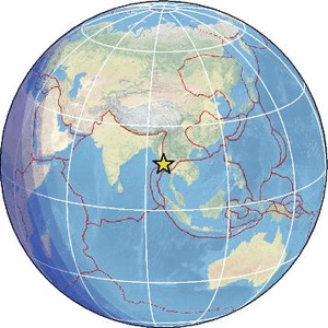
| Region | NEAR SOUTH COAST OF MYANMAR |
| Date time | 2026-05-18 02:05:24.3 UTC |
| Location | 16.443 ; 96.316 |
| Depth | 10 km |
| Distance | 368 km SSE of Nay Pyi Taw, Myanmar / pop: 925,000 / local time: 08:35:24.3 2026-05-18 44 km SSE of Yangon, Myanmar / pop: 4,477,000 / local time: 08:35:24.3 2026-05-18 |
Source parameters provided by:
National Earthquake Information Center, U.S. Geological Survey -- Golden, United States (NEIC)
All data providers for this event:
Seismological Survey of Serbia -- Belgrade, Serbia (BEO)HUN-REN EPSS Kövesligethy Radó Seismological Observato -- Budapest, Hungary (BUD)
Badan Meteorologi, Klimatologi dan Geofisika -- Jakarta, Indonesia (BMKG)
GeoForschungsZentrum (GFZ) -- Potsdam, Germany (GFZ)
Geophysical Survey of the Russian Academy of Sciences -- Obninsk, Russia (GSRAS)
Instituto Portugues do Mar e da Atmosfera -- Lisbon, Portugal (IPMA)
Kandilli Observatory and Earthquake Research Institute -- Istanbul, Türkiye (KOERI)
Instituto Geografico Nacional -- Madrid, Spain (IGN)
India Meteorological Department, New Delhi, India -- New Delhi, India (NDI)
National Earthquake Information Center, U.S. Geological Survey -- Golden, United States (NEIC)
The research institute NORSAR -- Kjeller, Norway (NORSAR)
EMSC -- Arpajon, France (SC4)
Thailand Seismological Bureau -- Bangkok, Thailand (TSB)
Further information can be found at:
Thailand Seismological Bureau -- Bangkok, Thailand (TSB)GeoForschungsZentrum (GFZ) -- Potsdam, Germany (GFZ)
National Earthquake Information Center, U.S. Geological Survey -- Golden, United States (NEIC)