| Magnitude | 5.7 |
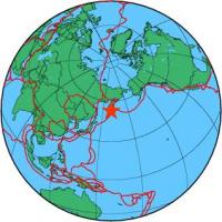
| Region | NEAR EAST COAST OF KAMCHATKA |
| Date time | 2011-07-26 06:17:37.9 UTC |
| Location | 53.145 ; 159.682 |
| Depth | 38 km |
| Distance | 1577 km ENE of Komsomolsk-on-Amur, Russia / pop: 275,000 / local time: 17:17:37.9 2011-07-26 71 km ENE of Petropavlovsk-Kamchatsky, Russia / pop: 187,000 / local time: 18:17:37.9 2011-07-26 |
All data providers for this event:
National Institute for Earth Physics -- Bucharest, Romania (NIEP)GeoForschungsZentrum (GFZ) -- Potsdam, Germany (GFZ)
Laboratoire de Detection et de Geophysique -- Bruyeres-le-Chatel, France (LDG)
Norwegian Seismic Array -- Kjeller, Norway (NORSAR)
Republican Seismic Survey Center or Azerbaijan National Academy of Sciences -- Baku, Azerbaijan (RSSC)
Geophysical Survey of the Russian Academy of Sciences -- Obninsk, Russia (GSRAS)
Bundesanstalt fur Geowissenschaften und Rohstoffe, German Regional Seismograph Network -- Hannover, Germany (BGR)
National Earthquake Information Center, U.S. Geological Survey -- Golden, United States (NEIC)
Further information can be found at:
GeoForschungsZentrum (GFZ) -- Potsdam, Germany (GFZ)National Earthquake Information Center, U.S. Geological Survey -- Golden, United States (NEIC)
Geophysical Survey of the Russian Academy of Sciences -- Obninsk, Russia (GSRAS)