| Magnitude | 6.0 |
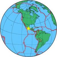
| Region | ESTADO DE MEXICO, MEXICO |
| Date time | 2012-11-15 09:20:23.7 UTC |
| Location | 18.483 ; -100.294 |
| Depth | 60 km |
| Distance | 81 km W of Iguala de la Independencia, Mexico / pop: 118,000 / local time: 03:20:23.7 2012-11-15 18 km NNW of Arcelia, Mexico / pop: 18,600 / local time: 03:20:23.7 2012-11-15 |
All data providers for this event:
Landsamt fur Geologie, Rohstoffe und Bergbau -- Freiburg, Germany (LED)Instituto Geografico Nacional -- Madrid, Spain (IGN)
National Institute for Earth Physics -- Bucharest, Romania (NIEP)
Seismological Survey of Serbia -- Belgrade, Serbia (BEO)
Laboratoire de Detection et de Geophysique -- Bruyeres-le-Chatel, France (LDG)
GeoForschungsZentrum (GFZ) -- Potsdam, Germany (GFZ)
The research institute NORSAR -- Kjeller, Norway (NORSAR)
Geophysical Survey of the Russian Academy of Sciences -- Obninsk, Russia (GSRAS)
Bundesanstalt fur Geowissenschaften und Rohstoffe, German Regional Seismograph Network -- Hannover, Germany (BGR)
National Earthquake Information Center, U.S. Geological Survey -- Golden, United States (NEIC)
GeoSphere Austria -- Vienna, Austria (GSA)
Further information can be found at:
Servicio Sismologico Nacional, Instituto de Geofisica, UNAM -- Mexico City, Mexico (UNM)GeoForschungsZentrum (GFZ) -- Potsdam, Germany (GFZ)
National Earthquake Information Center, U.S. Geological Survey -- Golden, United States (NEIC)